-
07542 928169
What Is The Dorset Council Local Plan 2025
Background
It’s important to understand that at this stage these are just PROPOSED sites, and that’s what we are here to talk about. If any of the sites are subsequently selected for inclusion in the Local Plan, the Parish Council would then need to incorporate them into the next revision of our Village Neighbourhood Plan, which provides us with the opportunity to attach our requirements on specifics such as development densities, retention of rural character etc.
Also note, that any subsequent planning applications that are put forward for such sites would still be subject to the same scrutiny and planning permission as per any other application.
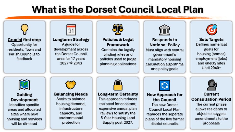
Crucial first step
This consultation is our initial, crucial opportunity to influence the plan, ensuring Dorset Council hears our objections, such as disproportionate housing, infrastructure failures, for example roads, drainage etc.
We must emphasise that this phase is not just open for Town and Parish Councils, but rather open to ALL residents, and it is important that you can let Dorset Council know your opinions and feelings.
Long-term Strategy
The plan sets the strategic context for the entire county until 2043, meaning the decisions made now will determine Shillingstone’s character for almost the next twenty years!
Policies & Legal Framework
This framework contains the policies proposals, and we are going to focus on one or two particular ones shortly, but the bulk of the planning policy, both national and local, will be included in the draft Local Plan next August.
If you’re wondering what policies Dorset Council will have for specific areas such as solar panels, EV chargers etc. that will be in clarified in that draft next year, so you won’t get that level of detail in this document.
As well as the proposed development sites across Dorset, there are other sections and questions, such as Infrastructure - question 8 – “Tell Us What Infrastructure You Need In Your Community”, this offers us the opportunity as a community to make ourselves heard on the topic of infrastructure.
There are questions on town centre regeneration, affordable homes, and much more, so what we would like to ask you all to do is when you fill this form in, which we know you’re all going to because that’s why you’re here tonight, fill in some of those other questions as well as this is your one chance to tell Dorset Council directly how planning does or doesn’t work for those of us who live in rural villages.
So, use those questions as an opportunity to put cross your thoughts on these matters in general, and not just the sites in Shillingstone.
There are also high-level proposals for locations for Solar and Wind renewable energy generation, but those areas are far broader and are more an exercise in looking at where energy infrastructure could go when the time comes to make such decisions.
Once adopted these will legally be used to judge future planning applications in Shillingstone and across the whole of Dorset.
Responds to National Policy
The key challenge is that the plan is driven by the government's mandatory housing calculations, Targets and Policies
Sets Targets
The plan defines numerical targets for Housing, Jobs, and Infrastructure, including Energy and Drainage. Some exceed our own proposals for our village.
Guiding Development
The specific allocation sites, such as LA/SHIL/003a, 3b, and 3c. These identify where Dorset Council is currently proposing to direct growth.
Balancing Needs
The plan is attempting to balance massive housing demand and supporting infrastructural needs with environmental protections, such as those of the DNL
Long-term Certainty
The Council seeks certainty, this approach reduces the need for constant, expensive annual plan reviews to satisfy a 5 Year Housing Land Supply.
New Approach for the Council
This single Local Plan replaces the numerous older district plans.
It creates a single, unified strategy for the entire county of Dorset
Current Consultation Period
This is the current phase where we formally submit our objections and propose amendments, such as requesting the withdrawal of the major sites and policies.
To be clear, this is not THE local plan.
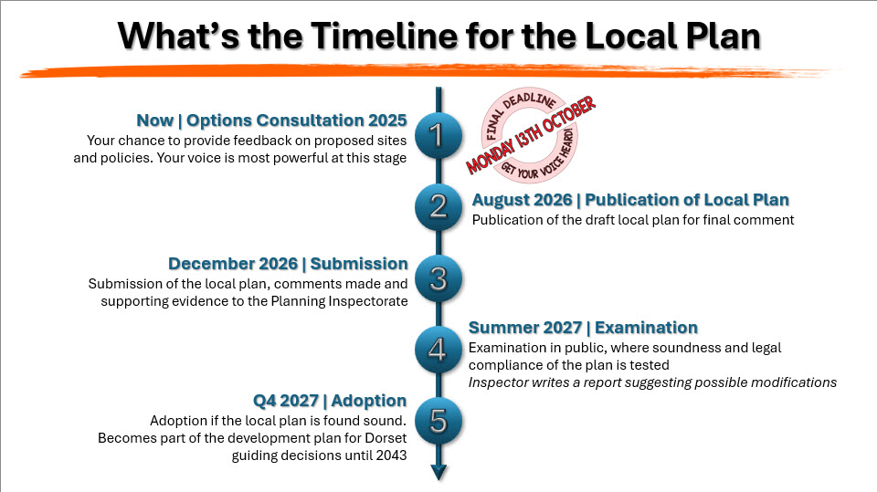
As you can see from the timeline on the screen, the Draft Version of the plan will be published in August next year for final comment. That offers a second opportunity for some comment and potential amendment, albeit a limited one, before the submission phase.
There are a couple of other phases ahead of the fifth and final “Adoption stage” in late 2027.
The consultation runs until Monday 13th October 2025, so we are pretty well into it already, with just a week left to get a response in if you haven’t already done so. That said, I can not emphasise enough how valuable a response from you will be – my apologies now, but this is a message you will hear repeated several times this evening.
So, what we are talking about today is Stage 1 - the consultation on possible sites for housing, employment land and travellers’ sites across the whole of Dorset.
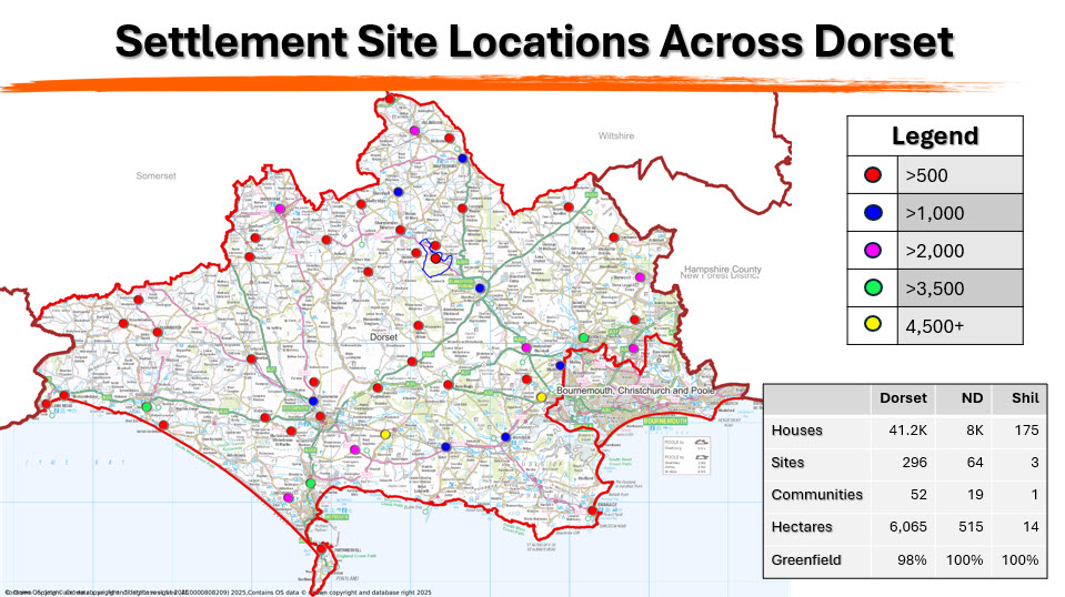
Settlement Site Locations Across Dorset
There are almost 300 sites across Dorset County in this consultation, most of which have been suggested by the owners of the land.
Dorset Council issued a ‘Call For Sites’ plea, so they gather all the landowners together and say, “tell us about sites you might like us to put in our Local Plan”.
That’s where most of these sites initially came from. Some have come from council offices from land owned by Dorset Council, such as the three fields in our Parish, which are owned by Dorset Farms, just to make up the numbers, but importantly not all of these sites will go forward into the Local Plan.
If your reaction to seeing the plans for our local villages, and if you think these are bad - take a look at locations such as Crossways or Lytchett Minster, is that they are concreting over our beloved Dorset, which to be honest is most people’s reaction to this, the reassuring point is that not everything in this consultation will get built. Between a third or more will be discarded as a consequence of this consultation. (4,700 & 5,500 homes respectively)
As the law stands, it’s not the Government nor North Dorset council that decides what gets to be built, it’s the national house-builders, the Barretts or Whimpy’s, who control house-building. Currently, neither the government nor councils can make them build something they don’t want to.
Less re-assuring is what actually gets build may not actually be in the plan at all; we know from experience, that what mostly gets built, what we mostly end up with, is unplanned speculative development which doesn’t deliver the homes that we want or need.
But notwithstanding the limitations of the local plan, it’s an absolutely vital tool to delivering the right development in the right places, and this consultation is really important for all of us, and we won’t be asked a second time.
Once the local plan is in place for 2027, that’s locked in place – it really is a fabulous opportunity for us as ordinary residents to input to the process of planning how our towns and villages will look like come 2043.
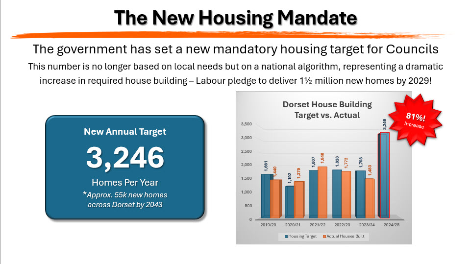
The New Housing Mandate
You may ask what’s the
driver to having so many sites?
In order to make good on its election promise of building 1½ million new homes
before 2029, the government have set new mandatory housing targets for all the
local planning authorities throughout the United Kingdom.
For Dorset the mandatory target set is 3,246 homes each year – precisely! How they got to that figure god only knows, but that’s about 55,000 new homes between now and 2043, which marks the end of this plan period.
Apparently, the government target is arrived at through complex algorithms, which we won’t go into tonight, but the objective is to address the actual pressing issue of the National housing shortage. To be clear, this is not in any way, shape or form based on any kind of assessment to meet the needs of the people of Dorset.
In the past the local plan used to be based on analysis undertaken by the county to understand the future housing needs of Dorset, but now the numbers are dictated to local authorities by central government.
So, if you look at that number and think we don’t really need that many houses in Dorset, you’re probably right.3,246 houses per year, that’s an increase of 81% over the previous target set for Dorset, and gets even worse. It equates to more than double the number of homes that are actually getting built at the moment, we’re actually building of around about 1,300 each year, about 40%of the figure demanded from Labour HQ.
The reality is that
housebuilders are unlikely to be able to deliver this
number of houses each year in Dorset.
Given that we all know the labour shortages in trades and material shortages
such as cement – with production in the UK at its lowest since 1950’s last
year, therefore we face the need to import these from overseas, and at
increased costs.
In any case, housebuilder business model is based on controlling supply to
maintain profitability – they are after all in business of making money, so
this is not entirely unreasonable.
So, we have a target set by government, which we have literally little hope of achieving, with sites in the local plan which may, or may not, get converted for many years to come.
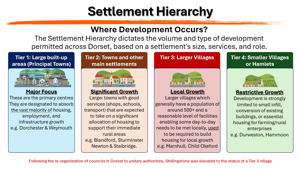
Settlement Hierarchies
This is one of the two significant policy changes we are drawing your attention to this evening. These have been a well-established part of Planning for a long time, but there are differing interpretations, depending on authority.
This slide tries to explain in simple terms what ‘Settlement Hierarchies’ are in relation to the DC Local Plan, which defines its settlement hierarchy as:
- Tier 1: Major conurbations - Primary focus for strategic growth e.g. Dorchester, Weymouth etc.
- Tier 2: Market and coastal towns - Key focus for strategic growth e.g. Lyme Regis, Swanage, Gillingham, Shaftesbury, Blandford Forum, Wimborne
- Tier 3: Larger Villages, generally with a population of 500 or more, and a limited but reasonable level of services and facilities such that some day-to-day needs can be met from within the village. In Dorset there are a total of 53 settlements that meet this tier 3 criteria.
- Countryside Policy: Other Settlements i.e. smaller villages and hamlets that don’t fall into any of the other categories due to size & their facilities will see some development, but it’s very limited. e.g. Ibberton or Fifehead Neville
Attributes Credited for Tier 3 Designation
Villages designated as Tier 3 were identified as having the highest level of sustainability among the villages. This designation meant they had a defined Development Boundary where small-scale, appropriate growth was generally permitted.
1) The key attributes that qualified a village as a Tier 3 Settlement included:
- A Primary School
- A Village Hall or other community facility
- A Shop or convenience store
- A Public House
- Public Transport access, connecting the village to the main towns and urban areas.
2) Employment Opportunities
The presence of existing employment sites, businesses, or small industrial areas, making it a place where people can both live and work.
3) Capacity for Growth
The settlement was deemed capable of absorbing a limited amount of new, small-scale residential, employment, or mixed-use development without fundamentally altering its rural character or overwhelming its infrastructure.
4) Proximity to Main Settlements
Often, these larger villages were well-connected to the main towns of North Dorset (Blandford Forum, Gillingham, Shaftesbury, and Sturminster Newton)
In summary, the designation is based on a sustainability assessment covering facilities, transport, and environmental factors. For Shillingstone, the challenges related to its linear form, traffic impact, and resulting poor internal accessibility typically outweigh its existing positive attributes, making it a less suitable focus for concentrated development compared to the designated Tier 3 settlements.
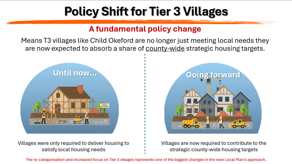
Policy Shift for Tier 3 Villages
Planning policy for Tier 3 – Larger Villages has changed recently.
They are now required to take a share of the strategichousing allocations for Dorset.
In the past Tier 3 villages were only required to build housing for local use, with no quota allocated specifically, we made our own assessment of what the need for housing was and that was what we were required to deliver.
However, at a planning appeal hearing earlier this year, the planning inspector ruled that given the new housing target figures dictated by Central Government, it was no longer reasonable for Dorset Council to argue that villages just met social needs, and that villages must now be prepared to help meet countywide needs.
This is absolutely a fundamental change, it means that we must expect to not only meet our parishes needs, but that of the wider needs of Dorset.
In essence the strategic expectation is to move away from blanket restrictions on growth and instead focus on sustainable, incremental growth that supports and ‘enhances’ the wider local community.
In essence, the strategic expectation for Tier 3 settlements is to deliver small-scale, highly sustainable, and locally supported housing that specifically addresses local needs and safeguards the long-term future of their ‘wider’ communities and services.
So, as long as the pressure to build homes remains policy of this government, it’s frankly unrealistic to expect tier 3 villages won’t have to grow under the current policies being pursued.
That opens us the obvious question, does Shillingstone qualify as Tier 3 in the settlement hierarchy? To be specific its Section 3, Question 3 in the Response Form, and is one we need to draw residents’ attention towards..
“Do you have any comments on whether a settlement is in the right Tier or not?”
When filling in the Dorset Council Local Plan Options Response form:
Section 3: The strategy for sustainable development
3.2. The Strategy for Dorset
Question 3: The proposed settlement hierarchy lists the towns and villages that will be the focus for new homes. Are there other settlements where we should plan for new homes? Do you have any comments on whether a settlement is in the right Tier or not?
This is where you can articulate your argument for removing Shillingstone from Tier 3.
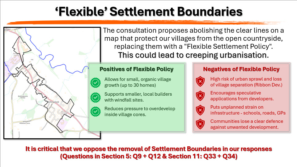
‘Flexible’ Settlement Boundaries
Currently, the traditional Settlement Boundary is a clear line on a map that separates the built-up area (where new development is generally supported) from the open countryside (where development is heavily restricted). In the map of Shillingstone, this is represented by the thick Black Line.
The requirement for larger villages to grow is the rationale behind an important policy proposal that we must draw to your attention.
This probably, other than the three sites proposed in our parish, is probably the single most important thing we need you to take action on when responding to the Local Plan.
The consultation is proposing a ‘flexible’ settlement policy, which removes the settlement boundaries from all villages.
The thinking behind this is to enable villages to expand, which as we have just explained we will probably have to, but with small developments of about 30 homes at the village edge. You might think this is better than the 175 homes they have proposed, however this policy would be as well as those proposed sites.
So, you’ll have the edge of your village and then you’ll see a smaller development tacked onto the side of your village - close to the existing settlement, thus avoiding the building of larger settlements off in the middle of the countryside – this is to try and avoid the randomness of developments we are getting at the moment.
There is some merit in this approach, and the idea does warrant further exploration by Dorset Council. However, what it most definitely doesn’t mean is we need to remove the settlement boundaries as a means to this end, because that end can equally be achieved by a well-crafted, well-written and well thought out policy - we honestly don’t need to take away the settlement boundaries to do this.
Settlement boundaries are absolutely the best defense we have against speculative development, and the kind of ribbon development we are seeing between our existing settlements, for example the creeping housing developments gradually edging towards us from Okeford Fitzpaine.
It’s that kind of development that is threatening to destroy the character of our villages and eats into our open spaces. We need our settlement boundary in Shillingstone to help preserve our village and oppose such speculative development at each entry point to the village; it’s been a very useful tool for protecting villages up until now.
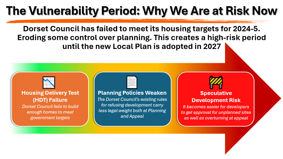
The Vulnerability Period: Why We Are at Risk Now
As a consequence of the high targets set by central government, and despite the energy of Planning Authorities working towards delivering to those Targets, the real answer to deliver said targets sits firmly in the hands of the House-builders.
The truth is that Dorset Council have not met their housing delivery targets for the 2024-25. Despite there being approximately 11,000 planning permissions in Dorset that have not yet been built out, and certainly if those 11,000 homes had been built, we wouldn’t be seeing this localised housing crisis, but still not enough homes have been built to meet the demand of central government.
This means that under planning regulations, from next month, development control policy that we use on planning committees to decide where development goes, will carry less weight as part of the planning decision process is concerned.
Put simply this will make it easier for house-builders to get approval for planning applications, as well as easier to get planning refusals overturned at appeal. Villages have become very vulnerable to unplanned speculative development between now and when the local plan is adopted in 2027.
Just because a site is NOT in this plan does not mean that between then and now that such a site couldn’t be but forward for development planning.
Once the Local Plan is in place sometime in 2027, it becomes much easier to resist these unplanned speculative developments.
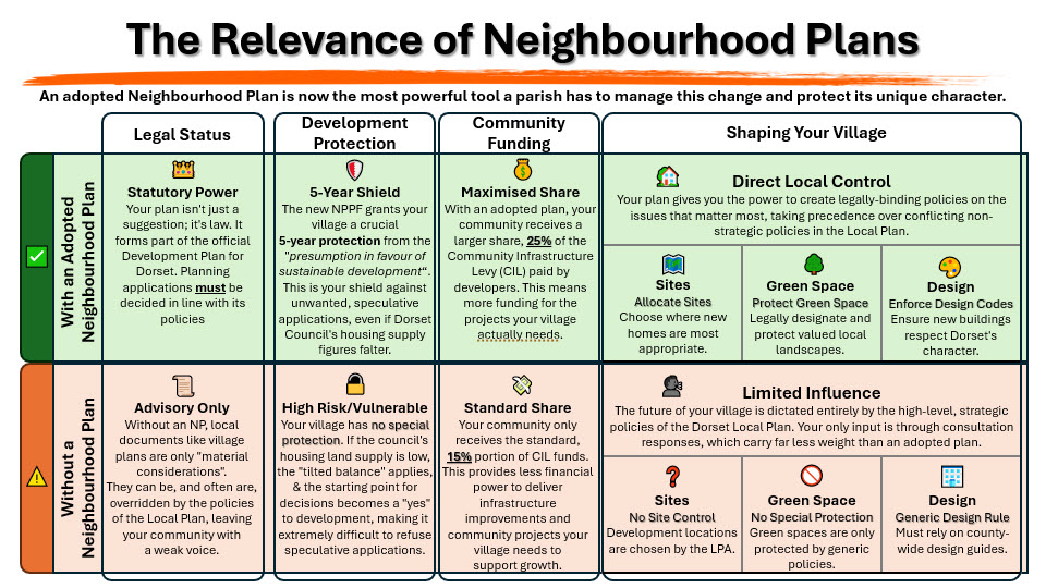
The Relevance of Neighbourhood Plans
During the course of publicising the Public Meeting I have been quite a few questions about the value and relevance of the Shillingstone Village Neighbourhood Plan, which we are on course to have adopted in 2026, incorporating it into the Local plan, given the emergence of the Dorset Council Local Plan.
Certainly, with the announcement of the removal of funding under the current government, they are sending mixed signals as to the future of Village Neighbourhood Plans, however, it does appear to be one of enhanced strategic importance in defining how development occurs, but with the caveat of an increase in pressure to accommodate ‘necessary’ housing targets set by central government.
While the Labour Party's core policy is to "get Britain building again" with mandatory national and local targets, they have also explicitly stated a commitment to localism and empowering communities to shape their areas.
Whilst the cost of a Village Neighbourhood Plan from scratch is estimated to cost around £10,000, and the need to refresh every 2-5 years to remain relevant, they are certainly a costly endeavour. As I stated, for Shillingstone this doesn’t pose to much of an immediate problem as we already has an established Neighbourhood Plan which is undergoing the final phases of a refresh.
The Slide hopefully shows that benefits of having a 'Made' plan over not having a Plan at All, and although there will be a shift in the deliverables for a Neighbourhood Plan to a position of ‘How’ rather than ‘If’. To clarify, this means there is an enhanced degree for which the community's voice is heard on 'How' housing will be built (i.e. over design, style, location within the village boundary), while challenging those who question 'if' the homes will be built at all. Incidentally, a village with a made plan also receives a greater share of the Community Infrastructure Levy (CIL - 25% to 15%); CIL's are due to replace the current Section 106 agreements in North Dorset once the Local Plan has been adopted.
Neighbourhood Plans remain the key mechanism for a village to define its design codes, local green spaces, and character, ensuring new development is appropriate to the rural setting.
Note:There are relatively few villages in North Dorset who have a 'Made' Neighbourhood Plan, these include Bourton (Jan-18), Fontmell Magna (Nov-18), Hazelbury Bryan (Mar-19 R24), Milborne St Andrew (Oct-19), Motcombe (Dec-19), Pimperne (Jan-19 R22), and Shillingstone (Feb-17 R25)
*Dates in brackets signify original dates when plan were made, with 'R' indicating subsequent refreshes.
Local Plan Policy Proposals That Require Rebuttal!
We can only get the full benefits from having a Neighbourhood Plan if we can say a firm"NO" to the proposed Policy Change on 'Flexible' Settlement Boundaries.
We must again draw residents to Section 5 of the Local
Plan Response Form, in Particular
Question 34– “Should the housing requirement figures
for neighbourhood plan areas outside the Green Belt, include an allowance for
sites that could come forward through the flexible settlements policy?
For the avoidance of any doubt - Shillingstone sits outside the statutory Green Belt.
The Green Belt in Dorset is confined to the south-eastern part of the county, primarily around the Bournemouth, Christchurch, and Poole conurbation. Shillingstone, being located in North Dorset, is not subject to these restrictions.
Therefore, Question 34 directly applies to Shillingstone Parish situation, as it falls under the category of a Neighbourhood Plan area outside the Green Belt.
This question is critical because the Parish Council is currently opposing the scale of housing and the removal of the Settlement Boundary
We need residents to definitively answer “NO”. to this question.
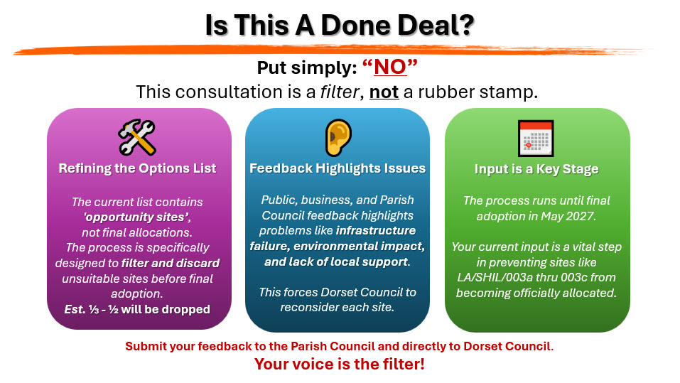
Is this a done deal?
Put simply NO
No, it is highly unlikely that all the proposed sites will be converted into the final adopted plan. The consultation process is specifically designed to refine the list of "opportunity sites" before they become officially allocated in the Local Plan.
A site's inclusion as an "option" doesn't mean it's automatically deliverable.
Feedback from the public, businesses as well as town and parish councils will highlight potential issues with sites, such as environmental impact, infrastructural limitations, or lack of local support. Dorset Council will then use this information to reconsider the suitability of each site.
This is why it’s important you have your say. Submit your own feedback and views. Tell your Parish Council your concerns, views and evidence about these sites.
The process of moving from the current "options" stage to the final adopted plan is a filtering and refining process, not a simple rubber-stamping exercise.
The public's input is a key part of this process leading to final adoption in May 2027.
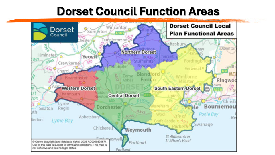
Dorset Council Functional Areas
The re-organisation of Dorset County Council in 2019 into the Unitary Authorities of BCP & Dorset Council, not only merged the functions of the five District Councils, it has also meant changes to the existing and understood areas, such as North, West, East Dorset etc. and just to add to the confusion, they don’t align with any other established boundaries, such as Parliamentary seats etc.
To understand the new ‘Functional Area’ of North Dorset, it stretches from Halstock (near Crewkerne) in the West to Chettle & Farnham in the East. And although the Boundaries to the North remain much the same, the southern boundary line falls just north of Blandford Forum at Durweston Bridge, so Blandford is no longer determined as being part of North Dorset; it strangely resides in Southeastern Dorset, which stretches down to Swanage in the South and almost Ringwood in the East.
This re-alignment of area’s has also seen a shake-up what Villages have been classified and assigned to Tier 3 status in each.
Shillingstone, therefore, has been subsequently designated as a Tier 3 Larger Village for planning purposes.
Growth and Infrastructure Principles
Growth in Tier 3 settlements must adhere to strict principles
- Proportional Contribution -Housing must be a proportionate and smaller share of the overall county need.
- Infrastructure-Led Growth -Development must align with and, where necessary, support existing infrastructure capacity (e.g., water, sewage, roads, GP’s, schools).
- Sustainable Travel -New housing should be within safe walking and cycling distance of essential local facilities.
- Development Type -Growth is typically concentrated on small-scale infill sites or carefully managed, limited extensions immediately adjacent to the existing settlement.